Processing of Aeromagnetic Data
The Geomagnetic field is caused by eddy currents in the viscous Earth's outer core (yellow in figure. The mantle (green) does not contribute to the magnetic field at all. The field varies slowly with time, so slowly that these changes can be predicted years ahead and because of the great distance to the source there are no abrupt changes in the field at the Earth's surface. The geomagnetic field is frequently referred to as the "Average field".
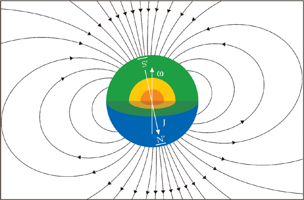
The geomagnetic field, here represented with field-lines around the Earth, is similar to that by a bar magnet situated at the Earth's centre, aligned semi-parallel to the rotation axis (ω).
Therefore the geomagnetic field can be represented in time and space with rather simple mathematical equations. In 1969 the International Association of Geomagnetism and Aeronomy IAGA released the first generation of the International Geomagnetic Reference Field IGRF which is widely used in studies of the Earth's magnetism. The model is updated regularly at 5 years interval, the 12th generatioin in December 2014.
Knowing the strength of the Geomagnetic field at the time and place of survey is necessary in order to extract the Rock Magnetism from the measured data.
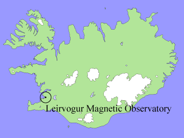 |
The approach to the "Geomagnetic field" has been a little different at the Science Institute, University of Iceland, mainly because the IGRF was not fully developed at the time when Thorbjörn Sigurgeirsson started surveying Iceland. He used data from high altitude (3 km) surveys from 1965 (1) and calculated a second degree equation of (x,y) which he referred to as "Average field", changing uniformly with time according to variations of the field at Leirvogur Magnetic Observatory Western Iceland. (2). |
|
(1) G.V. Haines, W. Hannaford and P.H. Serson: Magnetic anomaly maps
of the Nordic countries and the Greenland and Norwegian Seas. Publ.
Dominion Observatory 39, pp. 123-149, 1970. (2) Thorbjörn Sigurgeirsson - "Vísindafélag íslendinga - á ensku ath." |
|
Rock Magnetism is caused by magnetic minerals in the uppermost kilometre or kilometres of the crust and diminishes very rapidly with distance. At normal survey altitude it seldom exceeds 2000 nT, which is around 1/25th of the geomagnetic field in Iceland. It however may vary rapidly along survey lines. The rock magnetism reflects physical parameters of the crust such as chemical composition and alteration, and its thermal status. It also reflects the history of geomagnetism along with crustal buildup.
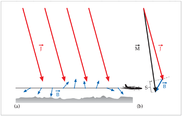
The figure shows the sum of the two vectors: Geomagnetic (J) and Rock magnetic (B). Actually, at normal flight altitude the geomagnetic vector should be around 5 times the length shown in figure! The real measured field may also include magnetic turbulence (E, not shown in figure) caused e.g. by solar wind and disturbances by the aeroplane and its communication system.
The proton precession magnetometer reads the length of vector M which is the vector sum of J and B (and eventually some error E). The length of the Geomagnetic field, (or "Average field") is calculated for this survey point, and subtracted from it leaving us with the scalar field S which we refer to as the "residual field", or the "anomalous field" or simply "magnetic anomaly". In its simplest way, here at high latitudes:
The Residual Field
can be referred to as
The vertical component of the rock magnetic field
can be referred to as
The vertical component of the rock magnetic field